Souter Point Lighthouse
Souter Point Lighthouse
HER Number
2489
District
S Tyneside
Site Name
Souter Point Lighthouse
Place
Marsden
Map Sheet
NZ46SW
Class
Maritime
Site Type: Broad
Navigation Aid
Site Type: Specific
Lighthouse
General Period
POST MEDIEVAL
Specific Period
Victorian 1837 to 1901
Form of Evidence
Extant Building
Description
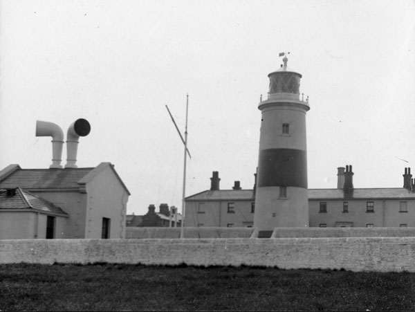
When it opened in 1871 Souter was the most advanced lighthouse in the world. It is sited on Lizard Point but named after Souter Point about one mile south, to avoid confusion with the Lizard Lighthouse in Cornwall. This lighthouse was designed by Sir James N. Douglas of Trinity House, with cottages for the engineer and four keepers, engine house, boiler house and workshops constructed together around a courtyard, the lantern housed at the top of a 75 foot high tapered stone tower, at a total of 150 feet above sea level. This lighthouse was the first specifically constructed to be powered by electric illumination. The original carbon arc lamps (now in the Science Museum) were replaced by oil in 1915 and then modernised with electric lamps in 1952. The original power hall forms part of a group with the lighthouse, workshops and houses. LISTED GRADE 2*. Built by Robert Allison of Whitburn. Decommissioned in 1988 and is today owned by the National Trust. The lighthouse is said to be haunted by the spirit of a former keeper and a man called Bob, a colliery worker who died in the lighthouse in the 1930s. Objects are said to vanish, especially in the engine room where tools often disappear, coinciding with a smell of tobacco smoke. A figure has been seen walking along the corridor to the staircase. In the kitchen female members of staff have been grabbed by unseen hands and cutlery pulled from people's hands {Kirkup 2009}.
Easting
440770
Northing
564160
Grid Reference
NZ440770564160
Sources
<< HER 2489 >> 2nd edition, Ordnance Survey map, 1898, 6 inch scale, Durham, 4, SE
I.M. Ayris, & S.M. Linsley,1994, A Guide to the Industrial Archaeology of Tyne and Wear, p.27,28 and 75
I.M. Ayris, 1988, Tyne & Wear HER, Souter Point Lighthouse File, SCT/ST/IA7
Tyne and Wear County Council, Marsden to Cleadon Leaflet
English Heritage, 1997, Monument Protection Program, Site Assessment, Step 4; Rob Kirkup, 2009, Ghostly Tyne & Wear, pages 89-90